مختصون في تعزيز الفرص الاستثمارية البلدية لتحقيق النمو والتنمية المستدامة. حيث يعمل فريقنا مع وكالات الاستثمار البلدية والمستثمرين لتحديد وتنفيذ المبادرات الاستراتيجية للاستثمار التي تسهم في تعزيز الفرص الاستثمارية البلدية وتحقق التنمية المستدامة للمجتمع.
للتواصل
الخدمات
- تحليل الوضع القائم
- حصر وأتمتة الأصول
- تحديد الاستخدام الأمثل ونوع الاستثمار
- عمل الجدوى الاقتصادية للاستثمارات المقترحة
- عمل كروت الوصف للأراضي وقرارات القياس
- تقديم الاستشارات القانونية حسب الاشتراطات واللائحة التنفيذية
- عمل كراسات الطرح والشروط
- متابعة أداء المستثمرين
- وضع الخطة التسويقية والبرشورات والإعلانات
Surveying Equipment
The company owns modern equipment, which facilitates the completion of field survey work in a short period of time and with high accuracy.
-
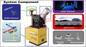
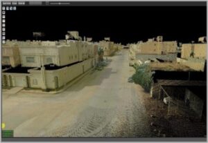
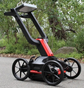
( LIDAR – Mobile Mapping System ) Topcon IP – S3
Mobile mapping systems are powerful tools that enhance the efficiency and accuracy of geospatial data collection and analysis. Their functions extend across various fields, including urban planning, surveying, transportation, and environmental monitoring, making them invaluable for modern mapping and data management.
-
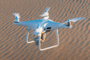
(Drone – RTK / PPK / VRS) EBee Plus
Drones are powerful tools to help in the mapping and surveying industry. They can effectively perform work for 3D mapping, land survey, photogrammetry, and topographic surveying by flying above the ground
-
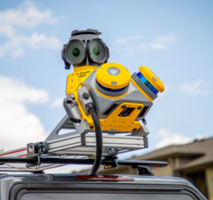
( Handheld 3D Laser Scanner ) ZEB HORIZON
Capture accurate 3D data of complex shapes, surfaces, and structures.
-
(GNSS Receivers) leica
GNSS receivers play a vital role in navigation, positioning, timing, and data collection across various industries
-
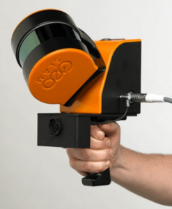
(GPR) MALÅ Easy Locator series
GPR is a versatile tool that offers non-destructive, high-resolution imaging of the subsurface. Its applications span various fields, including construction, archaeology, environmental monitoring, and forensic investigations, making it an invaluable technology for subsurface analysis.